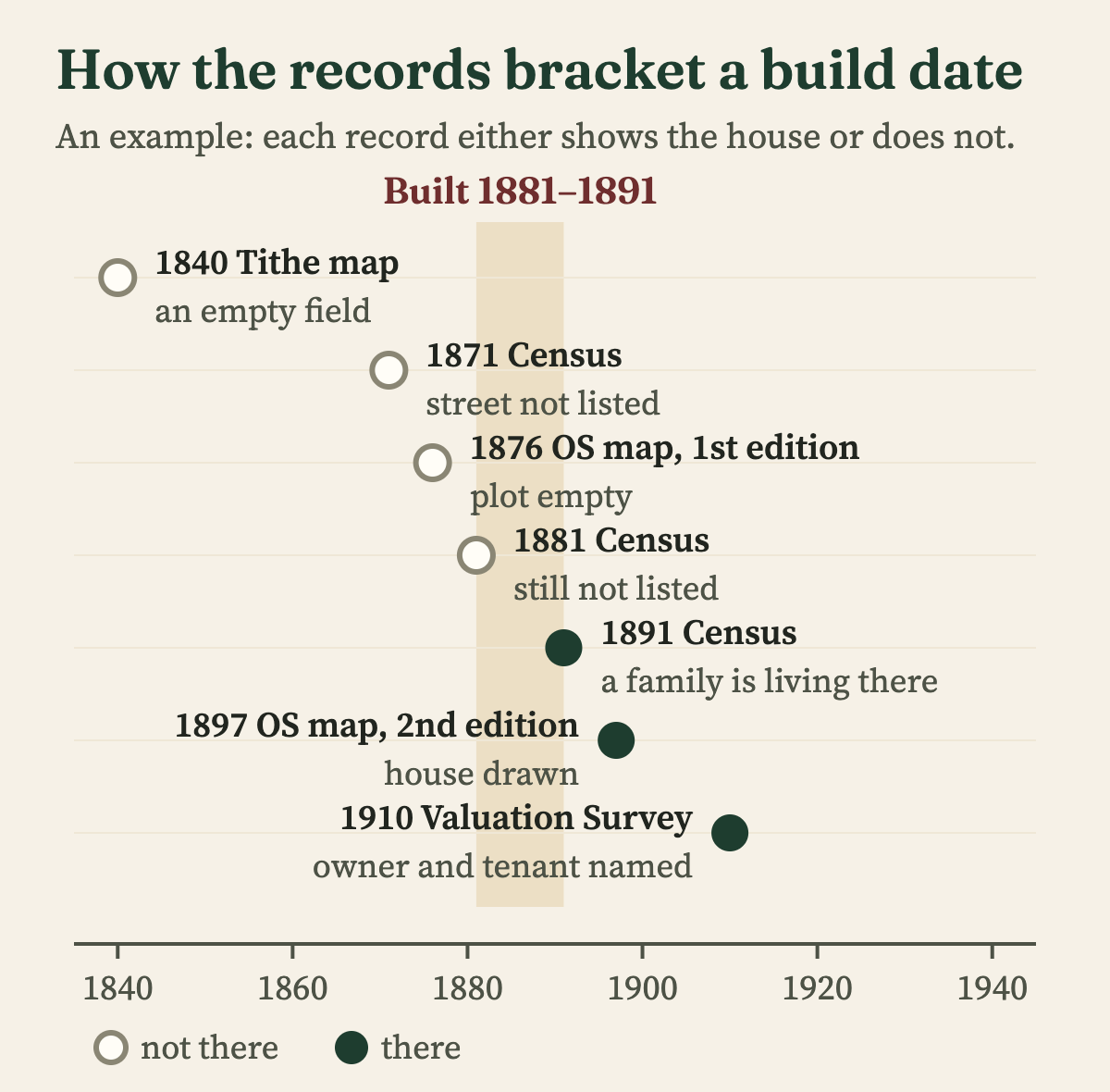
You can usually date a house to within a few years by putting three sources side by side: old Ordnance Survey maps, the census, and the listing entry if the house is listed. The maps show when the building first appears, the census shows when people first lived in it, and between them they bracket the build. The "built 1890" on the estate agent's details is almost always an estimate, so treat it as a starting point rather than an answer.
Here is the order I work in, and what each source can and cannot tell you.
Is there a quick answer in the sale details or the deeds?
Sometimes, but check it. Estate agents and surveyors estimate a date from the style, and a Victorian front can sit on an older core. Deeds are better: an old conveyance may say the house was "lately erected" or recite the sale of the bare plot it was built on.
If your deeds are with a lender or long gone, HM Land Registry sells the title register online for a few pounds. Be careful with what it shows. The "date of first registration" is when the property first went onto the register, often in the 1970s, 80s or 90s, not when it was built. The useful part is any older conveyance the register mentions, because that tells you the house existed by that date.
How do old maps narrow it down?
This is the single best free method. The Ordnance Survey began its detailed county maps in the 1840s, and most of England has a first large-scale edition from the 1860s to the 1890s, revised every twenty years or so after that. If your house is on one edition and missing from the edition before, it was built between the two surveys.
The National Library of Scotland puts these maps online free for England, Wales and Scotland, with a side-by-side viewer that lays the old map over a modern one. Look for the large-scale 25-inch and 6-inch county maps first. Zoom to your street, then step back through the editions until the house disappears.
Before the Ordnance Survey there are tithe maps, drawn for most parishes in England and Wales between the late 1830s and the 1850s. Each plot is numbered and matched to a written schedule naming the owner and occupier. Many county record offices have put theirs online, and some counties offer a full transcription.
Is the house listed?
Search the Historic England list for England, Cadw for Wales, Historic Environment Scotland, or the Department for Communities for Northern Ireland. A listing entry gives a date, usually in the form "early 19th century" or "c.1840", based on an expert reading of the building.
One trap catches a lot of people. Houses in a pair or a terrace are often listed together under one entry, filed under the first number, so "Nos. 20 and 22" will not come up if you search for number 22. Search the street name on its own and read every entry.
If your house is not listed, it may still sit in a conservation area. The council's conservation area appraisal often dates individual buildings and sometimes reproduces an old estate map.
What do the census and the 1910 Valuation Survey show?
The census was taken every ten years from 1841 to 1921, and every return names the people living in each household. If your street appears in 1881 but not in 1871, it was probably built in the 1870s. Search by street rather than by house number: numbers were often missing, changed, or reallocated, and in villages houses were simply "of The Green". The 1931 census for England and Wales was destroyed in a fire in 1942 and none was taken in 1941, so the 1939 Register fills that gap.
The 1910 Valuation Survey is less well known and often more useful. Every property in England and Wales was valued for a new land tax, and the surveyor's field book, where it survives, records the owner, the occupier, the rent, and sometimes the date and price of the last sale. TheGenealogist has put the field books for some areas online; for the rest they are on paper at The National Archives at Kew. If your house is in a 1910 field book, it was standing by then.
The same records name the people, so once you have a date, who lived in my house shows how to trace everyone who has called it home.
What does the building itself tell you?
The building is evidence too, but read it as a range of dates, not a single year. Long terraces of near-identical houses with rear wings are typical of the decades after the Public Health Act of 1875, which made building bye-laws standard across the country. A date stone or a name can help. House names often commemorated events, so a "Mafeking" or a "Ladysmith" was not named before 1900, though an older house can carry a newer name.
Be wary of fronts. Houses were often refaced or extended, so a Georgian core can hide behind a Victorian bay window. If the inside does not match the outside, the documents above will settle which is older.
Did the council keep a record of the build?
For houses built from the late Victorian period onwards, possibly. Many councils approved plans for new houses under their building bye-laws, and surviving plans are usually held at the county record office. For anything built or altered since 1 July 1948, when modern planning permission began, the council's planning register may show the application, often with the applicant's name.
What about Scotland and Northern Ireland?
The methods are the same; the records differ. In Scotland, the census and the valuation rolls from 1855, at roughly ten-year intervals, are on ScotlandsPeople, and the National Library of Scotland maps cover the whole country. In Northern Ireland, Griffith's Valuation from the mid 19th century and the valuation revision books that followed are at the Public Record Office of Northern Ireland, and the 1901 and 1911 censuses are free online.
A quick reference
- Ordnance Survey maps: built between two surveys. National Library of Scotland maps site, free.
- Tithe map and schedule: the plot, its owner and occupier around 1840. County record office, many online, mostly free.
- Census 1841–1921: who lived there in each census year. Ancestry, Findmypast or TheGenealogist, by subscription.
- 1910 Valuation Survey: standing by 1910, with owner and occupier. TheGenealogist for some areas, otherwise The National Archives at Kew.
- Listing entry: an expert's date for the building. Historic England, Cadw, HES or DfC, free.
- Land Registry title: owned and registered by a given date. GOV.UK property search, small fee.
- Building plans and planning register: the date of a build or alteration. County record office or council website.
Want someone to do it for you?
Dating the house is usually where a house history starts, and it is often the easy part. The rest is finding who built it and everyone who has lived there since, then telling it as a story. If you would like that done properly, my house history research covers it: I search the census, the maps and old newspapers online for you, and send you the finished history as a printed booklet.